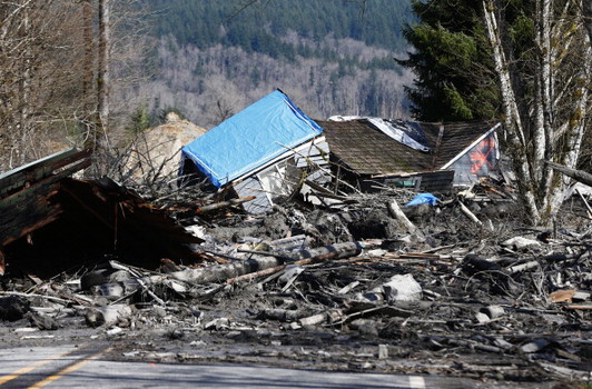
Bottom line is that the Seattle Area (Oso is just north of Seattle) has had heavy rainfall this winter. The heavy rainfall caused the Oso landslide, because that vicinity was prone to landslides. In fact that very hillside had had a landslide eight years ago. And the Washington Dept of Transportation had just finished a landslide mitigation project just across the river.
The rain we did not get in California instead fell in the Northwest, thanks to a semi-permanent high pressure system in the Pacific Ocean which redirected the normal winter rains northward. As a result California is having a severe drought, while the Pacific Northwest is receiving higher than usual rainfall.
Sea-Tac airport recorded 7.22 inches of rain between March 1 and March 16, 2014, or 3 times what is normally seen. While researching this I saw plenty of news reports from the Winter of 2014 about wetter-than-usual weather. In December 2013, KOMO News wrote a piece about 2013’s weather![]() , saying the two wettest months of 2013 were in months (September and April) that are typically dry months (for Seattle). Both of the months recorded rainfall 2-3 times the average for those months.
, saying the two wettest months of 2013 were in months (September and April) that are typically dry months (for Seattle). Both of the months recorded rainfall 2-3 times the average for those months.
Carbon dioxide from burning fossil fuels and destroyed tropical forests accumulates in the atmosphere, trapping heat that would otherwise escape into space, This trapped heat raises the planet’s average temperature. Some of the extra heat evaporates water from the ocean and soil into the atmosphere. Additionally, growing plants transfer water vapor into the atmosphere.
As average global temperatures rise, the warmer atmosphere can also hold more moisture, about 4 percent more per degree Fahrenheit temperature increase![]() . Thus, when storms occur there is more water vapor available in the atmosphere to fall as rain, snow or hail. Worldwide, water vapor over oceans has increased by about 4 percent since 1970
. Thus, when storms occur there is more water vapor available in the atmosphere to fall as rain, snow or hail. Worldwide, water vapor over oceans has increased by about 4 percent since 1970![]() according to the 2007 U.N. Intergovernmental Panel on Climate Change report, its most recent.
according to the 2007 U.N. Intergovernmental Panel on Climate Change report, its most recent.
It only takes a small change in the amount of water vapor in the atmosphere to have a major effect. That’s because storms can draw upon water vapor from regions 10 to 25 times larger![]() than the specific area where the rain or snow actually falls.
than the specific area where the rain or snow actually falls.
According to the U.S. Global Change Research Program’s (USGCRP) most recent report![]() , scientists have observed less rain falling in light precipitation events and more rain falling in the heaviest precipitation events across the United States. From 1958 to 2007, the amount of rainfall in the heaviest 1 percent of storms increased 31 percent, on average, in the Midwest
, scientists have observed less rain falling in light precipitation events and more rain falling in the heaviest precipitation events across the United States. From 1958 to 2007, the amount of rainfall in the heaviest 1 percent of storms increased 31 percent, on average, in the Midwest![]() and 20 percent in the Southeast.
and 20 percent in the Southeast.
After a heavy precipitation event, there is less water vapor in the atmosphere, and therefore dry spells tend to be longer. In the absence of rain, extra heat exacerbates drying and can contribute to longer and more intense drought periods.
USGCRP has projected that climate change is likely to increase the disparity![]() between light and heavy precipitation events.
between light and heavy precipitation events.
- Highway design could decrease death and injury risk, if “we” chose smarter designs - March 28, 2015
- GM really did trademark “range anxiety”, only later to abandon that mark - March 25, 2015
- US Government releases new regulations on hydraulic fracturing, that some call “toothless” - March 20, 2015
- Tesla Motors magic pill to solve range anxiety doesn’t quite instill range confidence - March 19, 2015
- Update on Galena IL oil train – 21 cars involved, which were the supposedly safer CP1232 design - March 7, 2015
- Another oil bomb train – why are they shipping crude oil by train? – Symptoms of fossil fuel addiction - March 6, 2015
- Chevron relinquishes fracking in Romania, as part of broader pull-out from Eastern European fracking operations - February 22, 2015
- Answer anti- electric car articles with truth and pride – truth outshines all distortions - February 19, 2015
- Apple taking big risk on developing a car? Please, Apple, don’t go there! - February 16, 2015
- Toyota, Nissan, Honda working on Japanese fuel cell infrastructure for Japanese government - February 12, 2015


